Forest Closures
The Caldor Fire has resulted in forest closures around the Basin. See below for information about which areas are currently restricted, and suggestions of open areas to recreate.
What’s Closed?
(Maps and details are included at the bottom of this page.)
-
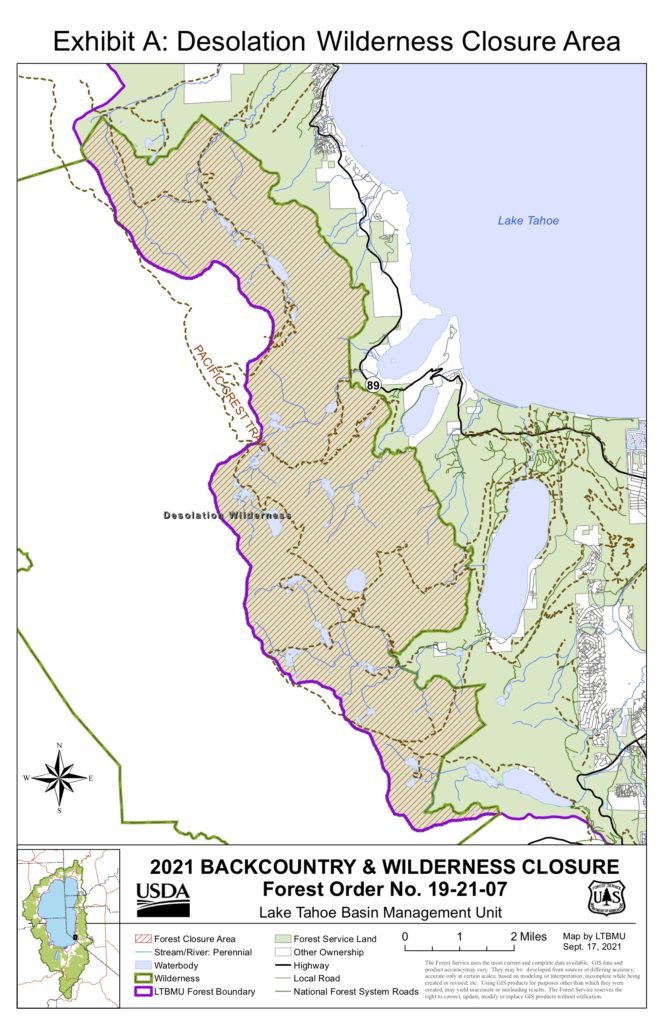
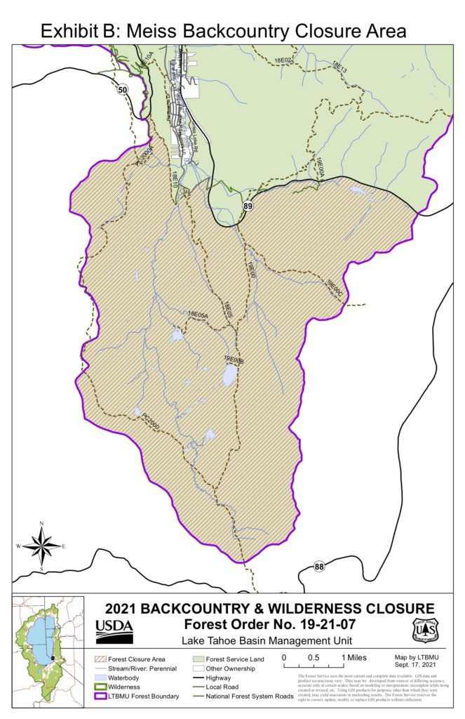
A Backcountry Closure keeps closed: Desolation Wilderness, Meiss Country, Rubicon OHV Trail, and Barker Pass / Blackwood Canyon corridors.
-
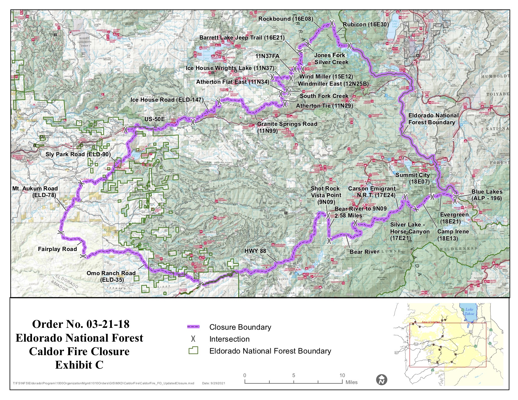
There are closures of the Caldor Fire affected area and access areas surrounding fire suppression repair.
-
The Caldor Fire Closure will be in effect until March 31, 2022, but could be lifted sooner or modified if conditions warrant.
-
The Tahoe National Forest is closed to dispersed overnight use.
Please respect all forest closures. If you are looking for open trails, look to the North and East shores.
Where Can I Go?
Here are a few suggestions for great open trails:
-
Incline Flume Trail
- The Incline Flume Trail, known as the “other flume” trail, runs from Mt. Rose Highway to the Tunnel Creek Trail above Incline Village. Its easy and flat terrain makes it the most family-friendly biking and hiking trail in the Basin.
-
East Shore Trail
- Dubbed as “America’s Most Beautiful Bikeway”, the long awaited Tahoe East Shore Trail is not only a spectacular way to recreate at Lake Tahoe, but also provides direct access to public beaches, coves and trails along the picturesque Nevada shoreline. Located in North Lake Tahoe nearest Incline Village, this new trail system lies below the highway bordering Lake Tahoe’s eastern shoreline providing unfiltered views and incomparable access to Lake Tahoe.
-
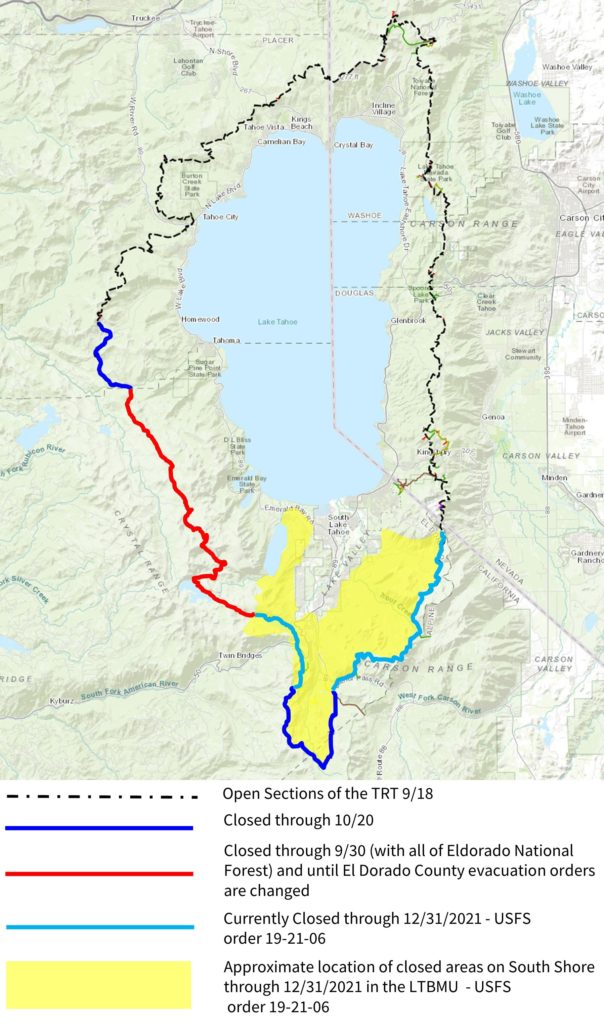
Tahoe Rim Trail (North of Homewood on the West Shore and north of Kingsbury on the East Shore, see map below).
- The TRT is one of the world’s premier trails, encircling one of the world’s most beautiful lakes, Lake Tahoe. While hiking the TRT, you will be treated to spectacular views of Lake Tahoe plus unlimited vistas to all points of the compass. Numerous creeks and lakes, ridges and meadows, can be accessed via the TRT. This variety of elevation and habitat provide an abundance of diversity of wildflowers.
- Current TRT Trail Conditions
- The Tahoe Rim Trail and Tahoe Rim Trail access from Barker Pass to Heavenly is closed.
-
Spooner Lake & Spooner Summit
- The Spooner Backcountry is a widespread recreational and natural oasis, with a lake surrounded by aspens and more than 12,000 acres of forested, open space. The park features 50 miles of hiking, equestrian and mountain biking trails and primitive roads. A few of the more popular trails are the Marlette, Red House, Flume and Tahoe Rim Trails.
-
Van Sickle Bi-State Park
- Van Sickle Bi-State Park is one the most accessible parks in the Tahoe Basin. A short climb from the trailhead quickly transports visitors to the serenity of the forest. The park’s easy to moderate trails are studded with rock outcroppings that present grand views of Lake Tahoe and the surrounding peaks.
Maps of Closures:
Tahoe Rim Trail:
The Caldor Fire Closure:
Backcountry Closure:
More closure details at these links:
- Lake Tahoe Basin Management Unit closure order
- Backcountry closure order
- Eldorado National Forest is closed until 9/30 at 11:59 pm.
- Eldorado County fire evacuation zone